
Vision Zero
Vision Zero Boston is our commitment to focus the City’s resources on proven strategies to eliminate fatal and serious traffic crashes in the City by 2030.
We are inspired by the belief that even one fatality is too many.
-
Have questions? Contact us:
What does Vision Zero mean for Boston?
Vision Zero Boston is the Boston Transportation Department's commitment to focus the City’s resources on proven strategies to eliminate fatal and serious traffic crashes in the city by 2030. We are inspired by the belief that even one fatality is too many.
While Boston has a relatively good record on traffic safety compared to many other cities, Mayor Walsh is not content to accept 20+ fatalities and 200+ serious injuries on city streets every year. Death and serious injury are not part of the cost of doing business in a busy city. That's why the Boston Transportation Department launched Vision Zero Boston.
Vision Zero Boston looks behind the statistics at:
- the human and economic cost of traffic crashes
- the barriers created by busy, high-speed roads in the heart of our City, and
- the impact of speeding on neighborhood streets that can limit access, mobility, and opportunity in communities that need it the most.
Vision Zero Boston makes traffic safety personal. Bostonians are going to meet the victims of serious traffic crashes and the family and friends of people killed on our streets. These are not just statistics, and traffic safety isn’t someone else’s problem.
Vision Zero Boston prioritizes safety and takes a people-first approach to transportation and community building. Most trips in the City of Boston are made by people on foot, bike, or transit. Everyone, including drivers, benefits from a transportation system that’s made safer for the most vulnerable road users.
Give input and view data
Input and data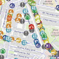
Safety Concerns Map
Help make Boston's streets safer. Select a location, and tell us your transportation safety concern.
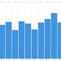
Crash report dashboards
View bar charts that aggregate crashes by type and month of occurrence.
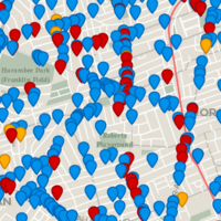
High Crash Locations and Corridors
High Crash MapsThe data is based on EMS responses and fatality data from Boston Police.
View an interactive map of high crash corridors and intersections.
The data is based on EMS responses.
Our work
25 in Boston
Boston has a new default speed limit. Learn more about why we made the change, and what you can do to help.
Boston's Safest Driver
Boston’s Safest Driver is a smartphone app that provides you helpful feedback on your driving based upon five metrics.
Safety Toolkit
Learn about our design tools that create safer crossings, safer turns, and safer speeds.
Current projects
See projects in your neighborhood that will advance safety for everyone using the street.
Better Bike Lanes
We're working on bike lanes that are safer for everyone on our streets.
Neighborhood Slow Streets
We use an equity lens to invest in traffic-calming on residential streets.
Reports and Updates
Reports and UpdatesPublished in 2018, this report provides a review of the progress that we made in the 2017 and the first half of 2018.
Published in 2017, this report provides a review of the progress that we made in the 2016 calendar year.
Our Vision Zero Action plan outlines our goals and how we plan to reach them.
Who's Involved:
-
Have questions? Contact us:
